If you appreciate the work done on this blog, please consider making a small donation. Thank you!

If you appreciate the work done on this blog, please consider making a small donation. Thank you!

Monday, December 3, 2018

Who's at the Banks Family Picnic?

The Banks Family
Since Mill Creek Hundred is a relatively small area, there are of course only so many families
involved in its first few hundred years of history. That being said, I always find it interesting when a particular family keeps popping up over and over again. And with a fantastic "new" picture shared with me recently, the family in question this time are the Bankses. Members of the Banks family have shown up in several past posts, including ones regarding the Jabez Banks Invitations, additional Banks Family items, and Automotive Pioneer Richard R. Banks. Another Banks brother, John W. Banks, also made appearances in a post about a barn fire and the one about the bunco steerers.

Of course, there were upwards of about a dozen Banks siblings milling about New Castle County in the late 19th Century, so it would kind of be surprising if we hadn't heard from them before. To the best of my knowledge, though, the only family members we had photographs of were Jabez Banks, Jr., his wife Sarah, and their three daughters Jessie, Bessie, and Annie. The good news is that now we a great photo that certainly contains more of the Banks family. The bad news is that we don't yet know exactly who is who in the shot. I'm fairly certain that Jabez is the guy behind the yellow dot. I also think his wife Sarah Chambers Banks is in the black dress in the back left. (You can click on the picture to see a larger version.)

Now maybe it's just me, but I happen to think that poring over old photos like this one is pretty fun. I've done very similar things recently with pictures of my own family, from roughly the same time period. I'd say this photo was taken somewhere around 1900, give or take a few years. I'd also say that the Banks men had a very distinctive look. I think I can smell the mustache oil. (Full disclosure: I have no idea what mustache oil smells like.) Down below is a picture of Jabez and one of him and family, for reference. In the group shot, I count at least seven or so guys that all look very similar. I'd be very surprised if some of those men aren't his brothers Richard, John, Edwin, Henry, Charles, and William.

Friday, September 14, 2018

Some Railroad-Related Pictures at Delaware Park

B&O culvert over Mill Creek
I admit to not knowing the full story behind the birth of Delaware Park and the selection of its site. But whether it was intentional or not, its proximity to not one, but two major railroad lines had to be at the very least a piece of good fortune. The property was literally bordered by the Pennsylvania Railroad (now the Amtrak line) on the south and the Baltimore & Ohio (now the CSX line) on the north. While passenger service was discontinued years ago by the B&O and the PRR (although it was revived by SEPTA in 2000), remnants and memories do still remain of previous era -- if you know where to look. And lucky for us, former Stanton resident, history lover, and friend of the blog Ray Albanese does know just where to look.

Over the summer, Ray returned to some of his old stomping grounds and took some amazing pictures, which I can't thank him enough for sharing with us. I posted these pictures recently over on the blog's Facebook page, and a number of interesting discussions arose from them. But for those who can't or don't access Facebook, I wanted to post the pictures here as well. Instead of trying to weave them all into some sort of semi-coherent post, I'll just show the pictures and include some sort of description with them.

Wednesday, May 30, 2018

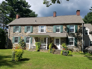
The David Graves House

The David Graves House
Note: The last few paragraphs of this post were updated with new information on 12/5/23

Longtime readers of this blog may know that something I find fascinating is the phenomenon of historic houses hidden back in the midst of newer, suburban subdivisions. As the farms of the 18th and 19th Centuries were sold off to make way for the housing developments of the 20th, the fates of the old farmhouses were really up in the air. Many were torn down to make way for the new, but some, if they were in good enough shape (and/or still owned by the farming family), were spared the wrecking ball. I'm grateful to the owners and developers who kept these old homes around, because many have rich histories and connections to the founding families of Mill Creek Hundred.

One such house can be found on Carillon Drive in Brandywine Springs Manor, off of Faulkland Road across from Brandywine Springs Park. This is the David Graves House, and it and its surrounding property have stories that trace back to the earliest days of Mill Creek Hundred, with some interesting personalities along the way. The field stone house that stands today certainly dates back to at least the mid-1800's, and there's reason to believe that part of it may be much older than that. Thanks in large part to the tireless work of Walt Chiquoine, the history of the ownership of the property is pretty well-understood. It certainly sits in an interesting corner of MCH.

The first European settler on what would become the Graves farm was a Scots-Irish immigrant named Bryan McDonald. In 1689, he was given a warrant for 239 acres by William Penn, followed in 1703 by two more for 154 and 200 acres. All three properties were surveyed in 1705 and a patent issued in 1706 for a total of 593 acres. As the figure below shows, the tracts were centered around what's now the Faulkland Road/Newport Gap Pike intersection. As you can also see, the site of the Graves House is located in McDonald's original 1689 parcel. Considering that the house sits along a ridge of high ground overlooking the surrounding area, there's good reason to think that McDonald's original homestead site may have been very close to the current house.

Thursday, May 17, 2018

The Denney-Morrison Farm -- Part II

In the last post we were introduced to the Denney-Morrison Farm, which was located along Old Capital Trail across from the entrance to Delaware Park. We first entered the story in the 1890's, when it was owned by Irvin L. and Clara Emma Ball. We traced its history backwards, going through the ownerships of the Morrisons, the Denneys, the Conners, and ultimately, back to the Balls. And while the property dates back to the early 1700's, I surmised that the house itself may have been built sometime in the the 1820's. The stately home survived until well into the 1900's, but its function (as well as its surroundings) had to adapt to the American Century.

It's fitting that our starting point for this farm was the Irvin L. Ball tenure, because it was at the close of his ownership that the property ended one chapter in its life and began another. On March 20, 1907, for the price of $5600, the Balls sold their 101 acre farm to Joseph Calvin Eastburn. Joseph was, of course, from the same Eastburn family that has been prominent in the area for over 200 years. He was a grandson of the family's patriarch David's eldest son, also named Joseph. Joseph C. grew up on his father's farm in White Clay Creek Hundred. As best as I can tell, it was situated along Salem Church Road, about where Christiana High School is now. I also think they later moved to Red Mill.

There is every indication that Joseph C. (or Calvin, as he also went by) bought the property as a farm, and used it as such for close to 20 years. By the early 1920's though, it looks like he was looking to move away from the farming life. In April 1924, Eastburn sold much of his farming equipment. This was fine, because that same year he began dividing up and selling off his land. The new development was called Eastburn Heights, and Joseph was busy in 1924 selling lots to those looking for a suburban setting. (Not, though, to everyone looking for such a place. In what I'd like to think is more a reflection of the times than the man, all Eastburn Heights deeds had the following restriction -- "No part of the said property shall be subject to the occupation or ownership of any person or persons of African birth or descent." And to be fair, there were also restrictions regarding building porches, houses, and having a business on the lot.) Eastburn held on to the farmhouse for a few more years, carving out about five acres for it on Lot #103 of Eastburn Heights.

Friday, May 4, 2018

The Denney-Morrison Farm -- Part I

The Denney-Morrison House in 1897
We are definitely fortunate to have in Mill Creek Hundred a good number of historic homes still standing and in productive use. That being said, it's also true that the vast majority of structures raised in the 18th and 19th Centuries have since been razed. If we're lucky, some of those few that have been demolished in "recent" times (say, the past 30 years or so) might have had the chance to be documented before their fall. However, countless old homes in MCH and beyond have been torn down with little or no permanent record of their existence, aside from their possible inclusion on one or more of the old maps.

Once in a while, though, we get lucky enough to come across a photograph of one of these long-gone houses. As you can imagine, the difficulty can come in verifying that the house in the photo is indeed the one you think it is, when you have no current structure to compare it with (Don Prather's Armstrong Tract posts are a great example of this). What can really help is another rare event -- finding someone who actually lived in it (or whose family did). In this particular case we do have both -- an old photo of a historic, lost home and confirmation of it from someone with a direct connection to it.

The investigation into the Denney-Morrison House (my name for it -- don't bother trying to look it up) began with an unidentified picture included in a cache originating from Gary Gilbert (and passed along to me by Denis Hehman). Gary is a descendant of the Gilbert/Ball/Cranston family featured in the post about the Edward Cranston House. I had actually had this photo for several years, but I had no idea where it was taken. Being included where it was, I sort of assumed it was in the Marshallton area. But, the more I looked at it the less it looked like any house in Marshallton I knew of. The faces are a bit blurry, but what I could see sure looked like Irvin and Clara Emma Ball. Plus, they did have daughters, and the kids in the photo definitely look like girls.

Friday, April 13, 2018

A Few B&O Culverts (Kiamensi and Casho Mill)

"A road near Kiamensi Mill"
When we think of pieces of railroad engineering, what usually comes to mind are the big bridges spanning rivers or creeks. Those are the big, flashy ones, but more numerous are the smaller tunnels and culverts put in place to allow small roads and waterways to pass under the tracks. Here we have two examples of such, one from Mill Creek Hundred and the other from White Clay Creek Hundred just outside of Newark. Both are about 135 years old, their purposes long since made obsolete, but still in pretty darn good condition.

The first one can be seen in the blue (cyanotype) photograph here, taken by the B&O during an 1891 survey of the line. It only says that it is a road near the Kiamensi Mill. There are actually two possible locations for this tunnel. The winner, as far as I know, is yet to be determined. The first possibility (and the one I originally assumed to be correct) is on the east side of Red Clay Creek, across from the former site of the mill. It was actually an extension of what's now Kiamensi Avenue, running from Newport Road (where the Judy Johnson House and the Kings Assembly of God (formerly St. Barnabas' Episcopal Church) are) all the way to Kiamensi Road. The full extent of the road can be seen in the 1893 map below. I have not seen this underpass myself, but I am told it is still there. It's filled in and very difficult to get to, but still there. It's very possible that the 1891 shot is of this structure.

Thursday, March 15, 2018

The Edward Cranston House

The Cranstons and their new home, c.1890
A little while back in the last post I wrote (about the Ferguson-Worth Farm), I noted that there had been several recent occasions where someone had inquired about a particular property, instigating an interesting investigation. This post is about another one of these situations, except with a slight twist -- the house I'm writing about is not the one I was asked about. I was originally asked about another nearby house, but as I started researching the larger property it was on I soon realized the significance of this particular home. I also realized that it fit into another story I knew a little bit about and a family I knew quite a bit about.

The house in question stands on Old Capital Trail near the western end of Marshallton. When it was built it may have been the "last house out", certainly on its side (north side) of the street. The land it sits on, like a lot of the area in the 19th Century, was owned by the Cranston family. Where we want to start, though, is with Joseph Cranston (1799-1872). Joseph, a son of family patriarch Simon Cranston, originally settled on a farm on the west side of Limestone Road above Stanton, about where Mannette Heights and Stanton Middle School are now. It was land acquired by the family through Joseph's mother, Mary Marshall Cranston, which she had inherited from her father William Marshall. After Joseph's older brother William died with no adult heirs, Joseph took over his farm. William's tract was on the east side of Limestone Road, just south of Kirkwood Highway. However, Joseph held on to his original farm.

Monday, March 12, 2018

Vignettes of Marshallton at Greenbank Mill (3/27/18)

Update: Due to possible inclement weather on March 20, the talk has been rescheduled for one week later, Tuesday March 27, 2018. Same time, 7:00 PM. Sorry if this inconveniences  anyone, but there's no reason to risk anyone's (including mine) safety. Hope to see you on the 27th!

As you may know, I've given talks the past few years at the wonderful Red Clay Valley History Talk Series, hosted by Historic Red Clay Valley, Inc. and the Wilmington & Western Railroad. The past two seasons I've done presentations entitled Vignettes of Marshallton. (BTW, thanks, Ray (or Tom, if it was you), for coming up with the title.) They've been fun journeys through the history of the village and the surrounding area, and NOT just an excuse for me to stand up and show a bunch of cool, old pictures. OK, maybe it was a little of that.

Well, in either case, I've enjoyed presenting these talks and we've had great turn-out for all of them. But on the off chance that you might be interested in hearing them and were unable to attend the first time (I can't imagine what would have been more important, but I'm willing to let that go), you're in luck -- I'll be giving each of the talks once more in the coming few weeks.

On Tuesday evening, March 20 March 27 at 7:00, I'll be presenting the first Vignettes talk at the Greenbank Mill. This is basically the same talk I gave last year, with only a few minor changes. Sort like the director's cut, but in this one Han still shot first. We'll look at the early history of the area (which actually does tie in with Greenbank), the two main mills, two churches, several stores, and few other odds and ends. There will be no written exam. Or any other kind. If you're on Facebook, you can find more event info here. Again, the talk will begin at 7:00 PM at the Greenbank Mill, 500 Greenbank Road.

Then a few weeks later on Sunday evening, April 8, I'll be giving the second Vignettes talk at the April meeting of the Friends of Brandywine Springs (FOBS). This is the "sequel" presentation I gave at this year's History Talk Series. It's similar to the first one, except for being completely different. This time we look at some of the area's historic schools, a few of the railroad-related items, a winding sojourn through one of the major area families, and then a few extras at the end. This will be held at the Cedars Methodist Church on Harrison Avenue in the Cedars (off of Newport Gap Pike, just south of Brandywine Springs). The FOBS business meeting begins at 7:00 PM, with the presentation commencing afterwards (sometime between 7:30 and 8). All are welcome at the meeting and the talk.

Friday, February 23, 2018

Armstrong Family Homestead Tracts at Mt. Cuba -- Part III

The South Armstrong property on Barley Mill Road
Here is the the final of Don Prather's three fantastic posts about the Armstrongs of the Mt. Cuba area. It's amazing that it all began with one old photograph and some old-fashioned curiosity. The first two posts (here and here) introduced us to the family and the properties, and attempted to prove the location of the photo. This post looks more closely at the south property and shows some other pictures of the house...or are they? You decide. Finally, we'll get an insight into what the home meant to the surrounding community. I can't thank Don enough for all his work on this. Great job!!

Researched and Written by Donald Prather --

More About the South Property
As stated in the previous post, when the south property was purchase in 1817, a stone house already existed on the property. Additional photographs acquired during our research, courtesy of Steve Armstrong, helps us understand the evolution of the house. I’m unsure whether the changes in the home represent additions to the original house or show a more extensive tear-down and rebuild. As the images below show, these changes were significant and altered the style of the home greatly but the footprint of the house doesn’t appear to have been altered significantly even as the style is updated. So, it’s possible that all of these pictures are of the same structure, but also possible that they are not. Regardless of the number of structures built, I’m certain that the properties pictured are the same because of the terrain, fence-lines, and relation of the house to the large barn and other surrounding buildings.

The earliest known image of the house can be seen in the image below. It shows a basic two-story farmhouse sitting in a fenced yard between two or three other buildings. The small building standing directly between the house and the camera appears to be a small blacksmith building or workshop with a tall chimney that appears to have been extended upwards at some point in time. It’s not hard to imagine a spark from the earlier, lower chimney causing a fire from a wandering spark or hearing the occupant of the bedroom inside that open window just a few feet from the chimney complaining about the constant smoke, heat, and the occasional hot spark. The house itself appears to be of stone construction, perhaps stuccoed-stone, but the image is not clear enough to be sure. When this first photograph was taken, the house had a simple gabled roof and at opposite ends roof are paired chimneys, penetrating the roof near the ridge with one chimney on the front pitch and the other chimney on the rear pitch.

Tuesday, February 20, 2018

Armstrong Family Homestead Tracts at Mt. Cuba -- Part II

The two Armstrong properties along Barley Mill Road
Here is the second of Donald Prather's three posts about the Armstrongs in the Mt. Cuba area and the quest to find the location of his Great-Grandmother Madolene's old photograph. In the first post, we were introduced to the photo and to the family. In this post, we'll look more deeply at the pair of Armstrong properties along Barley Mill Road, and begin trying to match the old photograph to a specific location. Thanks again to Don for his work on the project. Enjoy!

Researched and Written by Donald Prather --

The South Property, Original of the Two Tracts
As mentioned in the last post, the south property of 98 acres was originally purchased in 1817 by Archibald Armstrong. Archibald was a son of John Armstrong and a grandson of Archibald, both of whom arrived in the U.S. from Northern Ireland in the 1740’s (see notes 3 and 4). When purchased by the Armstrongs, the property contained a newer (2-3 year old) stone house and a barn, built by previous owners John and Esther Nicholson.

This south tract of land remained in the Armstrong family for 110 years and passed through four generations of the family:
  • Archibald Armstrong (original purchaser in 1817.. but likely never lived in the house)
  • Sold to his son John Armstrong Sr. (spouse Jane Delaplaine) in 1821
  • Willed to his son John Armstrong Jr (spouse Hanna K Woodward) in 1869
  • Transferred to his living children with son Joseph W. Armstrong (spouse Mary R. Guest) appointed trustee in 1913.
Joseph and his living siblings acquired the property in 1910 under the stipulation that all of his siblings (John Jr’s living children) were allowed use of the property, if desired, and had combined control over, and responsibility for, the operation, ownership, and costs of the property. Joseph was also required, as a part of the transfer, to acquire a bank loan in order to pay off the responsibilities of his father’s estate.

Thursday, February 15, 2018

Armstrong Family Homestead Tracts at Mt. Cuba -- Part I

Armstrong properties of the 18th & 19th Centuries
I want to introduce here the first of several guest posts researched and written by Donald Prather, a descendant of several MCH families (because, of course, no one comes from just one). As you'll see, this sojourn into a prominent MCH family and their holdings all started with a simple photograph found in a grandparent's attic, and the even simpler question, "Where the heck is this?" Great thanks to Don for all his hard work, and I hope you enjoy this as much as I did.

Researched and Written by Donald Prather --

Introduction
In his posts on the Mill Creek Hundred (New Castle County, Delaware) History Blog, Scott Palmer provides excellent insight into an area of northern New Castle County which came to be dominated by two groups of Armstrong family members from the late 18th century up through the early 20th century. The proliferation of properties owned by Armstrong families just north of Price’s Corner, along both Centre Road and Centerville Road, started with Robert Armstrong [(b) 1743 (d) 1821] and his purchase of the Hedgeland property, acquired some time prior to 1782. Opposite Hedgeland just across Centre Road, William Armstrong purchased and farmed a property known as Woodside, a property occupied today by the Ferris School. Just south of Woodside, across Faulkland Road, the Woodland and Brookland farms were owned and worked by generations of Armstrong families for over two centuries. And just to the northwest of these properties, down Faulkland Road and north on Centerville Road, was John Paulsen Armstrong’s Oakland farm.

Another early concentration of Armstrong family members in northern Delaware was located along today’s Barley Mill Road just south of Ashland in the immediate vicinity of the Mt. Cuba Center. This particular concentration of Armstrongs began in 1817 with a purchase of a 98 acre tract of land by Archibald Armstrong [(b) 1759 (d) 1826]. A later purchase of an adjoining property by Archibald’s son John more than doubled the size of the Armstrong presence in the area in 1842. The two adjoining properties that made up the “old homestead” consisted of 200 acres of some of the most scenic and bucolic piedmont in all of Delaware. At its peak, the combined properties contained at least three houses (one of which still exists today), barns, carriage houses, spring houses, and all the buildings necessary to maintain two working farms.

An Unidentified Photograph
This research effort started with a single unidentified photograph and the simple goal of attaching a location and a timeframe to it. Going in, I had no intention of researching or documenting this area. At the time, in fact, I didn’t even know the properties existed. But like many explorations of local history, the journey took me to new places, introduced me to new people, and taught me things about subjects I never intended to learn about. I never knew that a “looking glass” was mirror, or that a pump existed in the mid-1800’s that could deliver water hundreds of feet uphill without electricity or (nearly zero) manual effort [see note 1]!

Wednesday, February 7, 2018

The Ferguson-Worth Farm on Newport Gap Pike

Area of the Ferguson-Worth Farm, 1881
I've probably said this before (no, even I don't listen to everything I say -- please don't tell my kids), but one of the things I've come to really enjoy about writing this blog is when someone contacts me out of the blue with a simple-sounding question that turns into an in-depth, fascinating investigation. It usual starts with something like, "Do you know anything about such and such an area?" I say, "No, not particularly, but I can look into it." Then I do look into it, and I end up finding a lot more than I thought I would. And if I'm really lucky, I end up finding a few interesting stories along the way which, because it's Mill Creek Hundred, tie into other things I've researched. This has happened to me several times in the past few weeks alone, and I'd like to take the opportunity to tell you now about one of them.

This one started with an email from Beth Golden, who in the 1960's lived in the then fairly new neighborhood of Winterbury, situated on the east side of Newport Gap Pike, between Hercules Road and Loveville Road. Beth told me that she remembered an old, run-down stone barn standing in or near the development at that time. She wondered if I knew anything about the property or any of the families that had owned it. I didn't. My starting point, however, as with many of these investigations, was the old maps. The four 19th Century maps (1849, 1868, 1881, 1893) were evenly split between two names associated with the property. One led me back. The other led me forward.